Posts

Showing posts with the label closure

Electric Route 66 Dashcam: Oklahoma Pony Bridge
Image
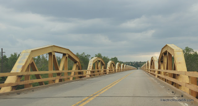
Today's dashcam video upload comes from the lovely Route 66 state of Oklahoma. We traveled here in October 2021, and several times we forgot to record our car's dashcam as we went! But we did remember to catch a section featuring the William H. Murray Bridge. Crossing the William H. Murray Bridge, also known as Pony Bridge, westbound This famous Route 66 bridge crosses the Canadian River a few miles west of El Reno, OK. It's often called the Pony Bridge, because it boasts a whopping 38 pairs of camelback pony trusses. Now part of US Highway 281, it was completed in 1933 and opened the following year as part of a new alignment of US 66, bypassing the towns of Calumet and Geary on the original, unpaved, 1926 alignment of Route 66. The 1933 alignment of Route 66 west of El Reno, OK     A view from the west end of Pony Bridge This bridge was Oklahoma Federal Aid Project No. 164-H We didn't have a ton of time to get back home from Oklahoma on this trip, so we stayed on the 1...
First road trip of the year

Image
February 21-22 marked our first weekend trip onto Route 66 for 2020. I had planned for this post to be the first in a series about several short trips we intended to make, but the recent pandemic has shut down much of the country and it doesn't look like there will be any more trips for a while! We hope to get back on the road as soon as conditions allow. For now, I hope you enjoy this account of our first Route 66 road trip of the year. Northern Arizona Route 66 weekender Route 66 in northern Arizona is among the closest places to access Route 66 from our home in Las Vegas, Nevada, so we took a short weekend trip to check out the route and see how things are going in 2020. Our first Route 66 destination was Kingman. While there we met up with a friend, Route 66 proponent and author Jim Hinckley. Jim is involved in the promotion of Route 66, showcasing Kingman and many other Route 66 locales, guiding travelers, and also provides expertise for the promotion of businesses both on ...

Road Closure info: Route 66 in California

Image
As many Route 66 travelers will know, there has been a long-term closure of a section of Route 66 in the eastern Mojave Desert in California. Due to the abundance of questions about this area on Route 66 Facebook groups, I decided to write up a summary of what is signed for travelers on the affected roads. Our October trip to the Road Runner's Retreat provided the opportunity to photograph all of the road signs that have been placed to deter travelers from the closed area. Two segments of Route 66 between Needles and Amboy have been closed for a couple of years, and there is no timetable for reopening. Many bridges were washed out in flood conditions and San Bernardino County has not finished repairing them all, as they are an enormous county without a lot of funds. After having a chance to photograph all of the signs, the source of travelers' confusion becomes clear: the signs are a jumble of contradictory and often wrong information. I will try to lay it all out here, ...