In an effort to get out of the Vegas heat once more, we took another short weekend trip at the end of August. We did our best to avoid the interstate and did a short loop around the back roads of southwestern Utah. I hope you enjoy our photos of some of the sights.
 |
Amazing views abound in southwest Utah
|
Day 1: Las Vegas to Cedar City
 |
Our two-lane route on Day 1: from I-15 exit 112 to Cedar City
|
For the first 75 miles of our journey from home in Las Vegas, using Interstate 15 is unavoidable as there is no other through road. We left home in The Blue Spirit with a full charge, which showed as 284 miles on our car. (This is just an estimate. I'm working on resetting the estimate back closer to the car's original EPA range of 310 miles, but this process of recalibration can take a long time in a Model 3.)
We exited I-15 at Exit 112 onto Nevada State Highway 170. This two-lane route mostly follows the alignment of old US 91 through Bunkerville and into Mesquite, then takes several different streets before crossing into Arizona, where the highway still bears the number 91 as a county road. The old highway turns north at Littlefield, veering well away from I-15 at that point.
 |
Entering Utah on old US 91
|
Since our route the first day was only about 200 miles, we did not anticipate needing to charge before arriving at our hotel. We decided to skip the Tesla superchargers in St. George and head up the back roads well west of the city. We left old US 91 near Shivwits and headed north on Gunlock Drive. This route took us past Gunlock State Park, and wound its way into the tiny town of Veyo from the west, where we met UT-18 and proceeded northeast through the communities of Brookside and Central, then ambled northwesterly again until we arrived in Enterprise. We took a brief cruise around this town of about 2,000, then once again headed northeast toward Cedar City.
 |
The Blue Spirit on Gunlock Drive
|
 |
Shem Dam, built by the Civilian Conservation Corps in the 1930s and repaired in 2015
|
 |
A great view on Gunlock Dr. west of Veyo
|
 |
At the edge of Enterprise
|
Northeast of Enterprise we left UT-18 in favor of a cutoff called Bench Road, and came out in Newcastle where we joined UT-56 eastward towards Cedar City. Most of our trips try to pack a lot of distance into a short time, so it was very nice this time to be able to just stop at any little thing that drew our attention. One advantage of taking two-lane roads in an EV is that the lower speeds use less energy than driving at 70+ MPH on the interstate.
 |
A display about the Old Spanish National Historic Trail, on Bench Road
|
We arrived in Cedar City with over 60 miles of range remaining despite some good altitude changes on our back road route. Our home for the night was the Best Western Plus Cedar City. Tesla still lists this business as having Destination Chargers, but they no longer do. However, they do still have a Clipper Creek J1772 charger, which we can easily use with an adapter we always keep on hand. This hotel property also contains a small RV park with 50 amp hookups, which is a possible backup in case there is a problem with the charger. The hotel property is pretty large, with a garden and patio, and even a giant chess set! At one end, the hotel is attached to a historic Union Pacific railroad depot that has been repurposed into space for an antique mall and restaurants.
 |
The historic Union Pacific Railroad Depot attached to the Best Western Plus Cedar City
|
 |
Giant chess, anyone?
|
 |
Charging at our hotel: 32 amps, 204 volts from this Clipper Creek unit
|
With the pandemic still in full swing, we chose to stay inside the hotel for a leisurely evening instead of checking out the town. We ordered dinner to go from Mandarin, one of the restaurants in the railroad depot. Pickup was just a quick walk past the patio. A good night's rest left us ready for day 2.
 |
Mandarin restaurant, at the depot adjacent to our hotel
|
Day 2: Cedar Breaks, caves and more back roads
 |
Our two-lane adventures on day 2
|
The Blue Spirit charged overnight using the Clipper Creek charger at the Best Western, and there were no other EVs staying there who needed it, that I could see. Charging went quite fast and would have finished in the middle of the night, so for battery health I set the charge limit to 90% initially. In the morning I increased the limit to 100% in the Tesla app, so that the car would reach 100% close to our departure time. We headed east from Cedar City on UT-14.
 |
We enjoyed a little rain after leaving Cedar City
|
 |
On UT-14 east of Cedar City
|
For the second day of our jaunt, our first goal was Cedar Breaks National Monument. Due to snow at that altitude, Cedar Breaks is not open during winter, but it's a great place for amazing vistas similar to Bryce and Zion National Parks, which are both much bigger and much busier. We took our time to stop at many pullouts and enjoy the cool weather with the windows down; it was wonderfully quiet when no other cars were near!
 |
Entering Cedar Breaks
|
 |
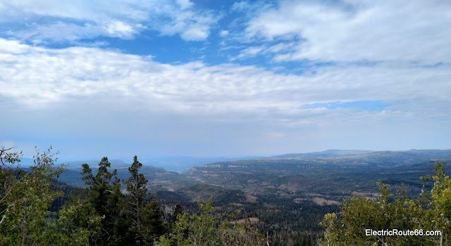
Grand vistas last for miles
|
 |
At the Cedar Breaks National Monument visitor center
|
 |
The views don't really stop impressing
|
 |
Chessman Ridge Overlook - altitude 10,460 feet
|
 |
The view from Chessman Ridge Overlook
|
 |
This is the scene from North View Lookout
|
We toured through the main part of Cedar Breaks on UT-148, then drove east on UT-143 into Dixie National Forest. We soon left the state highway to head south on Forest Road 050, and after a lot of fun, twisty road we left the pavement for a side trip to Mammoth Cave. Located at the end of about 2.5 miles of dirt and gravel road, this cave is nearly half a mile long with a surface opening. There were actually quite a few cars at the dirt parking area, including another EV: a Tesla Model X. We were not equipped to explore the cave, which requires good footwear and lighting, so we just visited the entrance a short walk from the parking area. There were picnic tables nearby so we decided to have lunch there. Unfortunately a bee arrived to our lunch break, followed by several more, so we had to retreat to our car to finish!
 |
An unexpected traffic jam greeted us just after we left Cedar Breaks
|
 |
This is not a quarry; miles of chunky volcanic rock cover the landscape
|
 |
The entrance to Mammoth Cave
|
After Mammoth Cave, we returned to paved roads and proceeded southward, back toward UT-14 at Duck Creek Village. Heading toward our second cave of the day, we just barely missed the open hours of Dixie National Forest's Duck Creek Visitor Center. From there it was another mile of off-pavement driving, sometimes quite rough, to Ice Cave. This cave is basically a big room-shaped space, with an opening near the top. Cold air tends to settle at the bottom so it can be near freezing even in the summer. After a short time at Ice Cave we hit the road again and headed back east on UT-14, passing through Duck Creek Village again and reaching US 89. From here we drove south, through the communities of Glendale, Orderville and Mt. Carmel. We had a lovely visit with the proprietor of The Rock Stop in Orderville.
 |
Parked in the wilderness to visit Duck Creek Ice Cave
|
 |
Ice Cave features a knotted rope to help you climb down into it
|
 |
| Glendale has visitor information for Grand Staircase-Escalante National Monument |
|
 |
| This vintage neon sign for the Parkway Motel caught my eye in Orderville |
|
| | | |
|
|
The Rock Stop in Orderville actually looks like a rock
| |
South of Mt Carmel Junction, we left US 89 on County Road 43, towards Coral Pink Sand Dunes State Park. By this time it was later afternoon and the state park was near closing, so we elected to pass it by this time and continued south. We arrived at the Arizona state line, where the road changed numbers from 43 to 237, and then after a short while the southbound road left the hills and made a sharp right turn, heading due west to come out at AZ-389. From there we proceeded north again through Colorado City, Arizona, which lies right next to the border with Utah. AZ-389 becomes UT-59, and proceeds northwest, ultimately descending a bluff into the city of Hurricane and ending at UT-9.
 |
The road goes ever onward
|
 |
Time to head back into Arizona for awhile
|
 |
The scenery doesn't care that it's not in Utah anymore
|
 |
Utah views just keep spilling over into Arizona
|
 |
Still in Arizona, near Colorado City
|
 |
Back in Utah again; can you tell?
|
At this point it was now evening and our carefree two-lane weekend was nearing its end. We stayed on UT-9 west until just before we reached I-15. We elected to continue avoiding the interstate and drove down Telegraph Road through the town of Washington, until we arrived at St. George Blvd. and drove it west through downtown St. George. At long last, we needed to charge the car to have enough power to reach home, so we headed up Bluff St. in St. George to the supercharger. Our leisurely day meant that we still had nearly 50% charge, so we only needed to add about 40 miles to arrive home with a comfortable buffer. After only 6 minutes of charging we had added 44 miles of range and were ready to leave.
 |
Just started charging, and even at half full it's charging at over 500 miles per hour
|
At 7:15 PM it was finally time to get back on I-15 to head home, with another EV weekend road trip under our belts.
 |
We made it back into Nevada in time for a sunset in Mesquite
|
Coming soon: a new video endeavor for Electric Route 66 that I hope will become a regular feature. Stay tuned!


Comments
Post a Comment